Pragati Gram
Partner: Haritikia
Background
Lying across the two states of Uttar Pradesh and Madhya Pradesh, Bundelkhand is among the hottest and most arid regions in India.
While agriculture is the predominant occupation in Bundelkhand land used for cultivation in the region is considerably lower than in other agricultural zones of the country. Bundelkhand region continues to remain susceptible to climatic shocks, which is attributed to the uncertainty of rainfall during monsoons and light soils with poor moisture retention characteristics. Low yielding crops, predominantly, in large tracts of single cropped areas the paucity of water, both for human and animal consumption, and large population of inferior breeds of livestock characterized the undulating and severely denuded landscape of the region.
There has been a drastic reduction in both surface as well as groundwater resources over the years, aided by the loss of forest cover and is regular rainfall, the latter also alternatively causing droughts and floods. Though yearly rainfall at 800 to 900 mm is plentiful, around 85% goes out of the region as runoff, with only 15% stored locally or percolating into the ground. The rate of groundwater recharge vary across the region, depending on the nature of the substrate. Groundwater levels have also been affected due to the gradual decline of traditional systems of rain for harvesting rainwater harvesting and indiscriminate use of tube wells and the installation of hand pumps. In the region the life of farmers have been considerably deteriorated during the last 7 years. Climate change has resulted in 58% decline and agriculture-based livelihood and food grain production as per the report of the planning commission. The marginalized population generates food grains through their meager cultivation and agriculture labor only for 3 to 4 months on an average in a year. So a large number of laborers are forced to migrate to other region of the country. In fertility of the land, low productivity, lack of irrigation and unscientific cultivation in terms of non-use of modern methods in agriculture and lack of marketing expertise have kept agriculture-based economy on the verge of subsistence only.
Thus in this region for making agriculture a sustainable source of livelihood, overall management of the drought situation in a structured and planned manner with optimum utilization of time and resources is essential, so that impact on community is minimized. There is no public sanitation system for waste water, excreta, or household waste. Government programs for rural electrification, street lightning and sanitation are poorly implemented.
Aims & Objectives
- Build 10 farm ponds.
- Build field bunding for 20 farms.
- On field bunding, plant appropriate trees and ultimately increse the production.
The broad objective of the project is:
- To augment groundwater in severe water-stressed area in Bundelkhand and to increase the productivity of drylands through a package of practices for Water Conservation.
- To impart the importance of water security and conservation in the low water table villages so that the water retention problem is ceased and soil fertility is resumed in the low-lying areas.
- To bring significant improvement in the quality of life among rural families by adopting an integrated development approach through convergence.
The project is about building farm ponds, building field bunding across farms and plant appropriate trees and ultimately increase the production in villages Panari and Narainpura.
Farm pond: Farm pond is a structure constructed on a farmer’s land to harvest rainwater, which would otherwise have flowed out of the farm. On flatter land in the village, streams are not very deep, nor do they have high embankment. Thus, it becomes difficult to build water harvesting structures like urban dams. In such flat lands, farm ponds are most effective water harvesting solution. The main objective of such structure is to provide protective irrigation to the kharif crop.
Size of Farm Ponds: A typical size of farm pond is top area = 20m * 20m bottom area = 14 m * 14 m and depth = 3 m with 1:1 side slope so that grass planting/sodding can be carried out on the inner side of the slope of the pond for the durability of the pond. The size of farm pond will depend on the land use, land slope, type of soil, annual rainfall, and catchment area. However, in cultivated area, where annual rainfall is at least 500 mm, the catchment area for this size of pond should be at least 1-2hecto and where annual rainfall is at least 1,000 mm the catchment area for the size of pond should be at least 0.5 to 1 hectare.
Potential Outcome: Total quantity of water stored will be nearly 880 cubic meters so 5000 cum. water can irrigate 1ha land with 0.5 depth of irrigation water, therefore 880 cum. water will be to irrigate 880/5000 = 0.176 hd land with single refill of pond, whereas, in normal rainfall there will be at least 2-3 refill of pond, which will be able to irrigate 0.176 * 2 = 0.352 ha land throughout the year i.e.in kharif as well as in rabi season.
Current Project Status
Haritika identified 10 beneficiaries for farm pond and bunding. List of beneficiaries names and their contact numbers have been shared with SIF. Haritika has completed one farm pond and five acre of fields bunding. The work has been paused due to lockdown and will resume on re-opening.
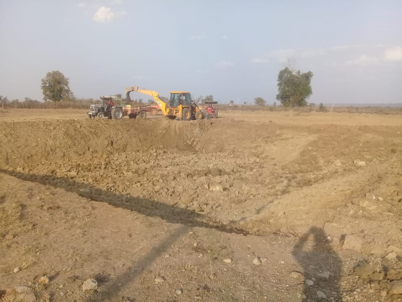
Work in progress for farm pond
Farm pond
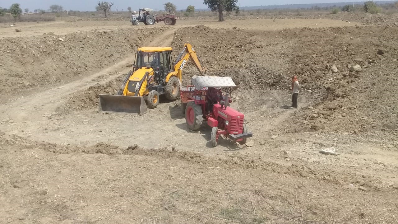
Work in progress in Pragati Gram
Events and Fundraisers

Recent News
Plant Sale – Mother’s Day May 2023
Backstory and Success Have you ever heard the famous saying …Read More »
Project Report – Utthan
Action-Programme Name: Inspecting the wells, solar pumps and shade nets …Read More »
A Visit to Johad
Action-Programme Name-To learn about the work of the Tarun Bharat …Read More »
Project Report – Borewell Recharge
Action-Programme Name- Visiting the borewell recharge site in Jodhpur and …Read More »